
Sources for Gilmer County Neighbors
Every neighbor lookup in Gilmer County starts with one subject parcel. From there, you build a list of nearby parcels off the map. A road search works too. The county viewer offers geometry and buffer controls, though it publishes no dedicated adjacent-parcel report. So open each surrounding polygon on its own. Then run the assessment search to pull its owner of record and parcel reference.
| Source | What It Shows About a Block | Access |
|---|---|---|
| WV Property Viewer | Parcel shapes and selected detail around a subject | Free online map |
| Assessor Street Name search | Multiple parcels and owner-roll fields along a road | Free assessment portal |
| Clerk plat and road books | Recorded lot layout, road, easement, and right of way | IDX search or Clerk request |
| Parcel assessment report | Owner, mailing, situs, value, and legal-description fields | Open a parcel record |
These sources describe land and recorded ownership, nothing more. They will not name every person living in a building. Keep in mind that a nearby parcel is not always an adjacent one. A road, a stream, or another tract can sit between the subject property and the one on your list. Read the geometry and the legal description together before drawing conclusions.
Mapping a Gilmer County Block
Start in the viewer with a parcel you already know. Zoom in until the outlines are crisp. Then work around the subject shape one polygon at a time. Keep a running list of every full parcel ID before you chase any owners. The geometry and buffer control may speed up selecting a group. But it does not produce a named adjacency report. Manual identification remains the dependable method.
- Search the subject by E-911 address or known parcel ID.
- Zoom to the parcel scale and use identify/highlight on each nearby polygon.
- Record the district, map, parcel, suffix, and legal description for every candidate.
- Search each ID in WV Assessment and compare its owner and mailing fields.
- Use a Clerk plat or road-book easement to check how the parcels relate on record.
- Parcel ID
- The record key built from district, map, parcel, suffix, and special ID.
- Adjacent parcel
- A parcel that shares a boundary line with the subject.
- Nearby parcel
- A parcel in the surrounding area that may not touch the subject.
- Buffer
- A geometry search area around a feature; Gilmer adjacency output is not confirmed.
Limits of a Gilmer Neighbor Lookup
The parcel roll lists the owner of record. It misses others tied to the building. A map alone cannot prove two tracts share a legal line. A displayed owner may leave co-owners off the screen. West Virginia's public-record law carries exemptions, and protected address programs can restrict disclosure, so when a record is withheld, ask the custodian directly instead of guessing from a map.
Lawful use. Use Gilmer County neighbor records for boundary questions, property diligence, and civic research. Do not watch, target, threaten, or harass people using parcel information.
Gilmer Street Searches Around a Parcel
The WV Assessment Street Name field can return every parcel along a road. For rural property or a block where the house number is unclear, it often beats the E-911 address mode. Type the road name, then work through each district, map, and parcel result. Each assessment record shows a legal description and a GIS parcel ID. That detail helps separate lots that sit close together.
A road list is only a candidate set. It does not prove every result touches the subject parcel. Confirm each one against the map geometry and the recorded plat. A road can cross unincorporated territory. Gilmer County's two incorporated places do not turn a ZIP code or postal city name into a boundary line.
The WV-5 street search shows the road-query format.
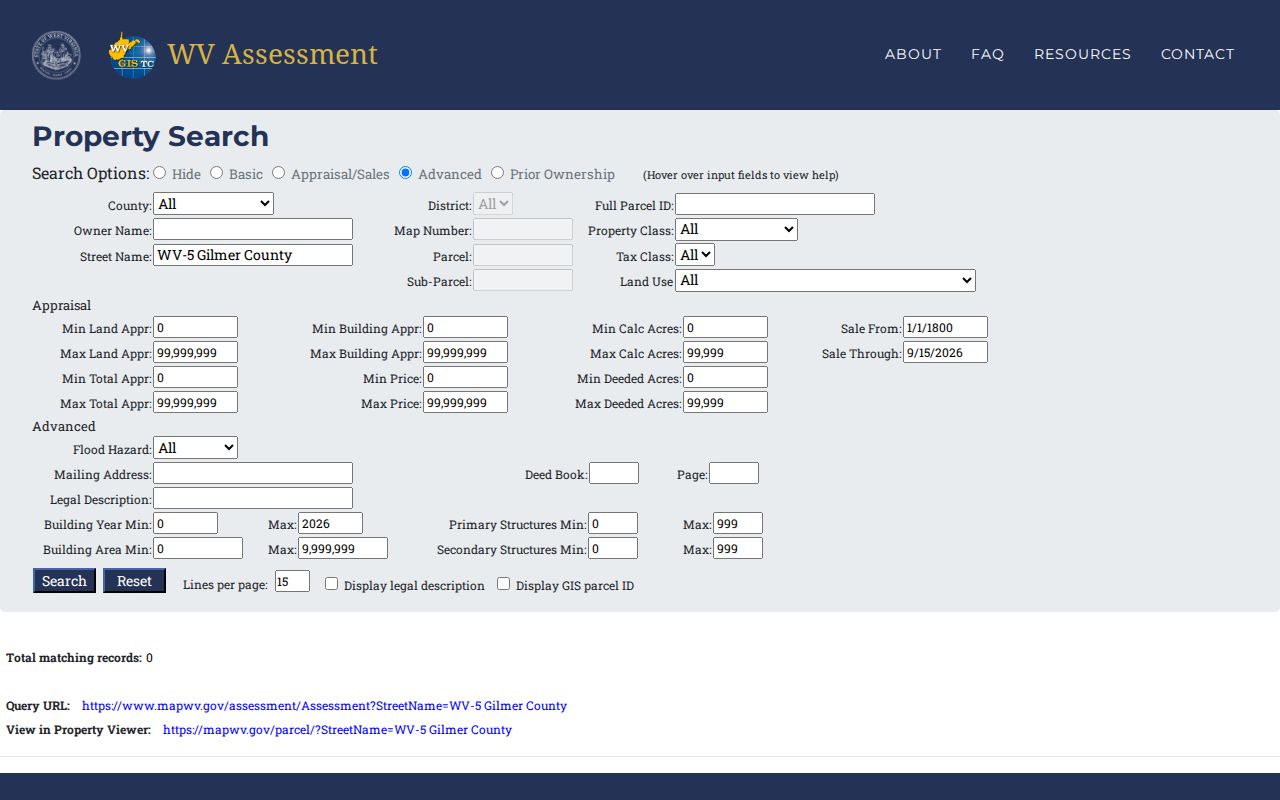
Build the candidate list from the road query, then confirm each parcel on the map.
Owner and Mailing Fields Nearby
Select a neighboring parcel. The Assessor portal can then display owner, mailing address, physical address, value, deed book and page, and legal description. Its parcel number also links into the state viewer. The tax portal adds map-parcel and billing address data. These fields tell different stories. A neighbor's mailing address may sit off-site. That is not evidence the parcel itself lies elsewhere.
The short WV map result can display a single owner. A deed may name several. Open the full assessment detail and the latest recorded instrument when a complete owner list matters. The county's standard record pages walk through individual owner lookup. This workflow stays on the block and its parcels.
Reading the Gilmer Parcel Geometry
The WV Property Viewer includes identify, highlight, geometry and buffer search. A close zoom level is where parcel boundaries display. One click can return several stacked map features. Check the parcel number in the detail panel. Confirm the shape you selected is the one you meant. The geometry tool can help gather adjacent parcels, but the viewer's help text documents no dedicated adjacent-parcels output.
Copy Link, KMZ download, and CSV export can preserve a map selection for later comparison. A saved map is still reference material. It does not certify a shared boundary. When the exact relation matters, compare against a recorded plat, deed, easement, or survey.
The WV Property Viewer supplies parcel, address, and map-selection controls.
Work through one polygon at a time and jot down its full parcel key first.
Plats, Roads, and Easements
Clerk records can explain why a parcel touches or reaches a nearby tract. Search Plat, Plat in Deed Book, and Plat Book. Also search Road Book Easement, Right of Way, Easement, and release instruments. A lot-and-block description may reveal a platted neighbor. Rural property may depend on a road, a creek, or an adjoining owner call instead. These records capture rights and layout that a tax polygon never shows.
Near Glenville or Sand Fork, postal place names can mislead. A postal place name will not tell you which side of a town line a parcel occupies. The WV transportation map marks the two incorporated places. The Census boundary map adds finer context where lines run close. Use those maps for geography, then come back to the parcel ID for the owner lookup.
Owners Are Not Occupants
An assessment record in Gilmer County names an owner of record. It also shows the tax mailing address. That is not the same thing as knowing who lives there. A parcel line can cross ground with no tidy street split. A trust or a business can hold the title too. Keep the lookup anchored to the land itself and the interests recorded against it.
To confirm current ownership of one parcel, use two sources. Set the latest deed beside the current tax roll. For boundaries, use the map and plat steps. A neighbor lookup is a property records question, not a census of residents. Do not use it to contact people. Skip reasons that have nothing to do with the property.
Build a Candidate Block Without Assuming a Roster
Gilmer County publishes no address-by-address neighbor directory. You can still build a candidate block by hand. The Street Name field in the assessment data pulls every parcel along a road. The WV Property Viewer shows each parcel's shape. A road list will catch land that never touches your parcel. Check geometry and legal descriptions one parcel number at a time. When a map click returns stacked features, write down the full district, map, parcel, and suffix before moving on.
The viewer's buffer and geometry tools can select nearby map features. It offers no dedicated adjacent-parcel report and no subdivision or HOA layer. For access or shared-line questions, the county Clerk IDX is the better stop. It indexes plats, road easements, and rights of way that often explain how two parcels connect. A town name or ZIP proves nothing about boundaries. Glenville and Sand Fork are the only incorporated places. Rural E-911 searches skip route and box addresses. When a boundary is the real question, trust a plat, deed, or survey.